Adventures of the Burnetts

Adventures of the Burnetts
Table Rock State Park - 2013

Wednesday, August 4, 2010

Update from NI

Our time here in Northern Ireland is quickly running out. The last few days haven't been quite as eventful as the weekend, but we have still been enjoying ourselves. We took it pretty easy on Monday after all of the hours spent in the car on Saturday & Sunday. Tuesday evening we took a short drive to Glenariff Forest Park and enjoyed walking some trails and even saw two beautiful waterfalls. The waterfalls were gorgeous but we noticed that the water coming down the stream was quite brown -- perhaps thats how Guiness gets its color!! I was even able to play a round of golf on Wednesday while Cori was at work. The course was pretty nice (even though it rained a little bit) and I once again enjoyed chatting with some locals during lunch. We are planning to head to Belfast tomorrow because we have an early flight out on Friday morning. We will probably try and take a bus tour of the city to see some of the highlights.


Glenarrif Forest - waterfall #1


Glenarrif Forest - waterfall #2


Manor House Golf Club


Hole in one!!..or not

Monday, August 2, 2010

Maps for Reference

We realized that it may be a little difficult for those of you reading this blog to get a good idea of all of the different places that we are talking about in Northern Ireland & the Republic of Ireland. So, as a quick overview I have attached two different maps with the routes that we have taken over the last fews days highlighted in blue. You can click on the picture or save it to make it bigger if you want to be able to read the small print.

To give you a reference that you may find meaningful, Northern Ireland is approximately 5,300 square miles which is about the size of Connecticut. The entire island of Ireland (i.e. Northern Ireland + the Republic of Ireland) is only 32,500 square miles which is about the size of South Carolina. So even though it looks like we are taking excessively long drives, you need to remember the scale that we are talking about. Still, very little of the driving is taking place on what we Americans would call "major highways" - mostly we are driving on smaller two lane (& sometimes only 1 lane) roads similar to what you would see between the smaller country towns in SD & SC, etc.

Our route on Satuday, July 31


Our route on Sunday, August 1

Northern Ireland: Day 5

We spent Sunday exploring more of Northern Ireland’s coastal regions. We started our day at the Giant’s Causeway which is a spectacular scenic attraction made up of 40,000 basalt columns that extend from the foot of the cliffs into the sea. The local legend is that the Giant’s Causeway served as a battleground between the Irish giant Finn McCool and Scottish giant Benandonner.


A view of the Giant's Causeway from above
Columns that make up the Giant's Causeway
Giant's Causeway!!
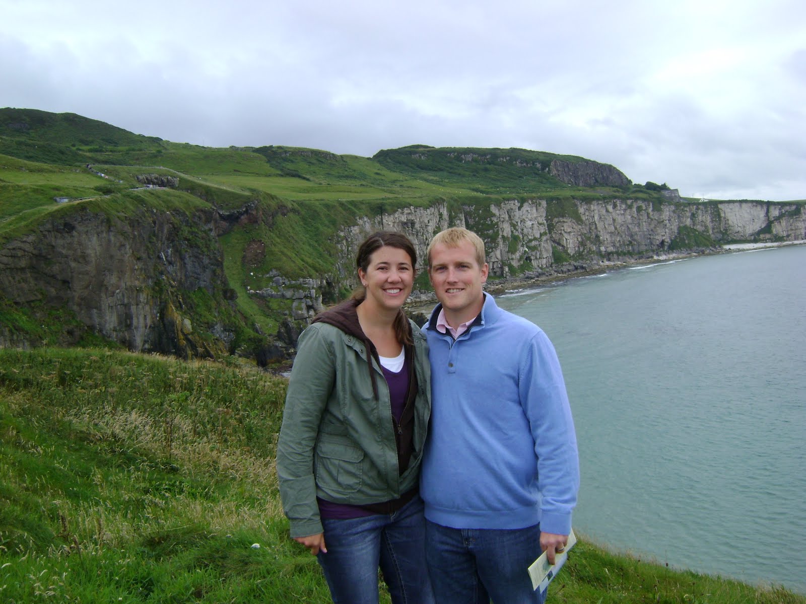
We continued down the Causeway Coast (the coastal highway along the northern region of Northern Ireland) to the remains of the 16th century Dunluce Castle which is set right on the cliffs overlooking the ocean.
Dunluce Castle
A view of the surrounding cliffs from Dunluce Castle
Next, we grabbed some lunch in Bushmills and took a tour of the Bushmills Whiskey Distillery. The tour lasted about 35 minutes, and we learned about the process and ingredients used to make Irish whiskey. All whiskey produced at Bushmills is made from just 3 ingredients: malted barley, water, & yeast. The primary difference between Irish whiskey and Scottish whiskey (scotch) are the methods used to dry the barley (scotch barley is typically dried over peat moss which gives it a more smoky flavor) and the number of times the whiskey is distilled (scotch is distilled twice, Irish whiskey is distilled three times). After the tour, we were able to sample one of Bushmills’ whiskeys and spent some time chatting with a group of folks that we met on the tour from California.
Bushmills Whiskey Distillery

One of our last stops for the day was the Carrick-a-rede rope bridge. As its name says, it is literally a rope bridge that connects two small islands along the coast. The original rope bridge was constructed over 350 years ago as a means for local fisherman to have the best access to catch migrating salmon. Over the years, the bridge has been fortified to accommodate the large number of visitors to the site who come to enjoy the same views and high thrills!

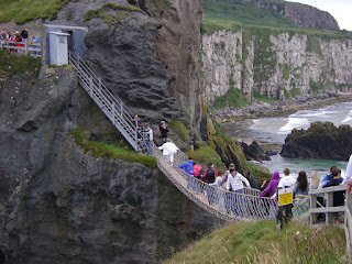
Carrick-a-rede Rope Bridge...don't look down!!
Carrick-a-rede Island
We finished our day with drive around the remainder of the Causeway Coast. We stopped for dinner in the lovely little coastal village of Cushendun and enjoyed some great food (Cori – salmon & cider; David – steak & Guinness). As we were getting ready to leave the restaurant, we started speaking with some locals who had just sat down to eat. One of the gentlemen offered to briefly leave the restaurant with us so he could get a map from his car outside and recommend a few places for us to visit during the remainder of our trip! Like we have said, people here are so friendly and we have really enjoyed getting to chat with some of the locals. A little way down the road, we stopped in the quaint little fishing village of Carnlough for some icecream and then headed back to Ballymena so that Cori could get ready for another few days of work this week.
The food & drinks were so good that we had to take a picture!
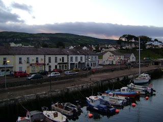
Carnlough Village

Sunday, August 1, 2010

NI and Ireland: Day 3 & 4

At the beach in Castlerock

We went to the Northern Ireland MILK Cup Championship games on Friday night in Ballymena. The MILk Cup is supposed to be one of the most prestigious soccer/football (depending on where you’re from) tournaments in the world. Ironically, Northern Ireland Elite played the USA Elite for the trophy. We were able to cheer on the USA to a 3-0 victory. Us Americans were a little outnumbered and we wished the NI’s could have scored a goal because the place would have gone crazy.

Saturday we spend the day driving around Northern Ireland and the Republic of Ireland. We started at an ocean village called Castlerock. It was right on the ocean and was an adorable place. We enjoyed walking on the beach and seeing all the gorgeous surroundings. We were definitely wind-blown after our walk, some of the locals said a storm was coming so we hurried to the car just in time for it to start raining. We made our way up the coast a few miles to Mussenden Temple and Downhill Demesne – the ruins of a home and temple built by Earl Bishop Hervey. The buildings are built right on the cliffs overlooking the ocean. Sadly, the home fell into disarray and it nothing more than the surrounding walls.
We got back in the car for a nice, scenic drive to the town of Derry/Londonderry. It uses both names because of its proximity to the border of Northern Ireland and the Republic of Ireland. The city center is surrounded by a large brick wall which allowed us to circle the city from above. We enjoyed some of the sights including – St. Columb’s Cathedral, Guild Hall, and many shops and pubs.


Mussenden Temple on the Cliffs


Entering the walled city of Londonderry

From there we made our first trip into the Republic of Ireland. We knew we didn’t have a lot of time to spend touring Ireland, but we wanted to say we had been there so we had planned to drive across the border, get out of the car and stand on Irish soil, then head back for more sightseeing in NI. Once we started looking around we couldn’t help but continue on further down the Irish roads – many of those only one-lane wide. We basically toured the entire Inishowen Peninsula (the northern most region of the island). We were literally at the end of nowhere. Our drive consisted of sunny skies followed by spinkles and down-pours of rain (repeat cycle over and over), sheep in the road, and some of the most breathtaking view of the ocean we have ever seen! The greenest grass and fields met the bluest ocean – with specks of white (sheeps) and black (cows) scattered throughout the green. Our tour of the peninsula included the northern most point in Ireland – Malin Head, which also fittingly had the northernmost pub serving, of course, Guiness! We drove through the Gap of Mamore – a very steep and winding road that cuts through some of the areas higher elevations. It was an awesome view – probably one of the top highlights from our day! Most of our drive was right on the coast – we feel very lucky to have experienced this area. It doesn’t seem like a normal tourist destination, but we are very glad we could make the trip!

Up the hill into the Gap of Mamore - watch out for sheep!

Heading back down....

So worth the view!!

The short time we spent in Ireland only made us hungry for more and we hope to return to the Republic of Ireland very soon!
The end of Ireland!